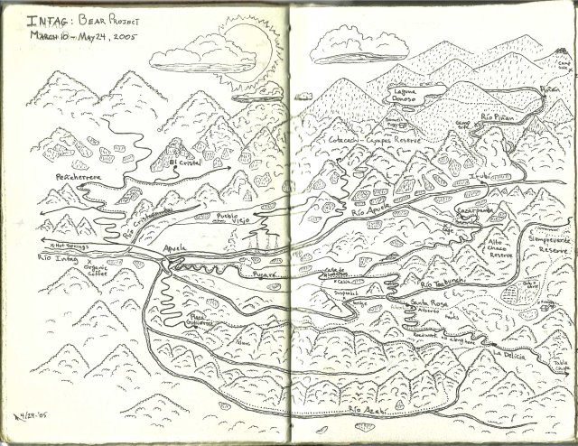
I love maps.
Maps tell convoluted stories in a seemingly simple, clean interface that belies the effort and planning that goes into constructing an understandable map. The one below is one I drew after working for several months in this particular portion of Ecuador, but it is only one of the many, many ways the area could be represented.
During graduate school I was the TA for several courses where map making was one of the essential skills being taught, both old school with a compass and your stride length, and with the newer GIS methods. Even though I had been making maps for various jobs ever since high school and had recently learned how to use ArcGIS, I didn’t realize how difficult it is for many people to understand what makes a map that is useful and pleasant to look at.
A good map, to me, is a work of art, it is something that you want to look at because it is interesting and beautiful on its own visual merits. It is something that draws you in and encourages you to learn new things while tricking you into thinking you are just looking at something pretty.
This page has a partial list of some good mapping and GIS resources. I will be adding to this heavily over time as I have many more sources bookmarked that I need to process. Some of these resources require a login (usually available via a free account) to access the data.
The Weather and Climate page also has some GIS links.
Keep in mind that within the US each state has a publicly accessible GIS clearing house, as do more and more cities.
As with all, please feel free to offer suggestions to especially good and useful resources.
AgroAtlas
http://www.agroatlas.ru
Huge amount of free agriculturally focused ecology, species, and physical features data in map and GIS form provided by both the USDA and a variety of Russian organizations.
Biota of North America Program
http://www.bonap.org
Phytogeographic and Botanical databases for vascular plats all through the US with many incredible maps. Especially the species Density Gradient maps indicating relative plant diversity across the US.
Cal-Adapt
http://cal-adapt.org/data
Climate change information, maps, data, and tools for California
Confirmed Meteor Impact Site KMZ (Google Earth file)
www.gearthblog.com/kmfiles/impacts.kmz
NOTE: this link is to a file and will open Google Earth
Conserve Online – Resiliency Modeling
http://conserveonline.org/workspaces/ecs
Resiliency modeling dataset for the Eastern US
Consortium for Spatial Information
http://www.cgiar-csi.org/data
A collection of climate based global data sets
Data Basin
http://databasin.org
Wide variety of environmentally themed GIS data
Diva GIS
http://www.diva-gis.org/Data
A variety of global GIS sources
Earth Resources Observation and Science Center (USGS)
http://glovis.usgs.gov
Global imagery, varying resolutions, searchable by time or pass. Includes visual and multi-band. Some extremely large files.
Google Earth Engine
http://earthengine.google.org
A set of Google Earth derived datasets, time-lapses, maps, and satellite images. Currently in test phase requires sign-in with Google account to become a “trusted user”.
Hey What’s That?
http://www.heywhatsthat.com
A viewshed generator that is linked with Google Earth and panoramic photographs
IUCN Redlist Spatial Data
http://www.iucnredlist.org/technical-documents/spatial-data
Global IUCN species maps. Extremly large datasets.
Map of Life
http://www.mappinglife.org
Species range and sighting maps taken from a variety of sources including citizen science projects
NASA Earth Exchange
https://nex.nasa.gov/nex
MODIS, LANDSAT, and other data sources plus links to data management and manipulation tools
National Atlas “Streamer”
http://nationalatlas.gov/streamer/Streamer/streamer.html
An interactive watershed/stream exploring map that allows for up and down-stream explorations
National Map Viewer (USGS)
http://viewer.nationalmap.gov/viewer
Seamless DEM data for the US and a host of other resources
National Snow and Ice Data Center
http://nsidc.org
Great collection of snow and ice info, maps, historical weatherdata, and GIS data from a wide variety of sources
Natural Resources Canada
http://geoapps.nrcan.gc.ca/applications/0/all_tout
Climate change and plant occurence GIS data amongst others. Difficult to find doata at times, but it is there.
Planetary Habitability Library
http://phl.upr.edu/projects/ser
From the University of Puerto Rico at Arecibo, this is a mapping project aimed at, among other things, generating photorealistic visualizations of exoplanets. The tool, Scientific Exoplanets Renderer (SER), is not publicly available yet. The page has an example of Earth rendered using this software.
Pollen Viewer
https://www.ncdc.noaa.gov/paleo-search/study/5973
Animated maps of species specific vegetation changes over the last 21,000 years in North America, courtesy of NOAA
SEDAC Gridded Species Richness Maps
http://sedac.ciesin.columbia.edu/data/collection/species-v1/sets/browse
Data sets of various species categories, some global, some Americas only
http://sedac.ciesin.columbia.edu/data/collection/species-v1/maps/gallery/search
Pre-made species richness maps
TNC GIS Data
http://maps.tnc.org/gis_data.html
TNC owned lands, various ecoregions, conservation projects, etc
TopoView (beta) – USGS
http://ngmdb.usgs.gov/maps/TopoView
USGS archive of downloadable historical topo maps explorable in a graphical interface with a date slider and dedicated search option.
UNEP Page of Graphics and Statistics
http://www.unep.org/geo/geo4/media/graphics
A page of high resolution charts provided by the UNEP showing a number of development and environmental trends broken down by region.
USGS Earth Explorer
http://earthexplorer.usgs.gov
A user definable global map with a variety of search options and a wide array of data types available. One nice search option is a date range. A free account and a log-in is required to access the data.
USGS Planetary GIS Webserver PIGWAD
http://webgis.wr.usgs.gov
A fantastic set of GIS files for Earth and other planets in the solar system
Web Soil Survey
http://websoilsurvey.nrcs.usda.gov/app/HomePage.htm
USDA/NRCS soil information for the USA. A very detailed soil/mapping site that provides information far beyond just the soil types.
WorldClim
http://www.worldclim.org
Global climate data including predictions
WWF Conservation and Science Tools
http://worldwildlife.org/pages/conservation-science-data-and-tools
Similar to the TNC datasets plus more, including several GIS tools
